

Cape Breton's Iconic Road Trip: Driving the Cabot Trail
/
Cape Breton Highlands
A Weekend Driving the Cabot Trail
*This post contains affiliate links, meaning I may make a referral fee if you purchase a product or service through my link. I only make recommendations when I truly LOVE something, and it won’t cost you a LOONIE more. Thank you for helping to keep this little blog afloat.
Cape Breton is absolutely dripping with natural beauty. It’s the kind of place landscape photographers dream about. Rolling mountains covered in hardwoods, dramatic cliffs falling into crystal blue sea, quaint little towns surrounded by beaches and fields lined with golden hay. Dreamy doesn’t even begin to describe Nova Scotia’s northernmost place. An island connected to the mainland by just a short causeway.
With a population of just over 130,000 in the entirety of its landmass, Cape Breton Island is a peaceful place and an excellent spot to relax. It’s a place where small town charm runs thick. And I mean that.
If you choose to visit, you will meet some of the kindest, most helpful people working local tourist stops; including restaurants, golf courses, tour companies and so much more. The Cape Breton accent is one of my favourites in the world because it reminds me so much of kindness.
If you, like me previous to our trip, have never been to Cape Breton, you must look into it…. especially if you’re an East Coaster. The island is such a gem representing the true beauty and heart of the Maritimes. The Cabot Trail is just a small piece of what makes Cape Breton special, but is the region I will be discussing below.
Quick Tips for Visiting Cape Breton, Nova Scotia
Eat a donair (To be fair, donairs were created in Halifax, but Cape Bretoners do them well!)
Have a craft beer (ie. Big Spruce Brewing) or sample single malt whisky at Glenora Distillery
Listen to fantastic Cape Breton fiddlers
Drive the Cabot Trail
Hike the Skyline Trail
Go Whale Watching in Pleasant Bay
How: The Cabot Trail can be driven by car, or if you are much more ambitious than myself, biked!
When: Summer is peak tourist season, Fall for magnificent colours in the Highlands.
Where to stay: Check out this stunning, modern rental in Margaree, near Chéticamp called Adonai Adventure Cabin.
Explore Chéticamp
We arrived in Chéticamp around suppertime after a long drive from Southern New Brunswick. While I should have been tired from a day on the road, I was far too in awe of the mountains in the distance to think about sleep.

Aside from being gorgeous, Chéticamp makes a great base for exploring because it is on the edge of Cape Breton Highlands National Park, and has all the amenities needed for a relaxing weekend.
Pro tip: Make reservations! Maybe it was a fluke when we visited, but we noticed most activities (with limited space) and restaurants encouraged reservations. We were never turned away at a restaurant without a reservation, however, we noticed the majority of tables were reserved when we walked in most establishments, including at breakfast time!
Whale watches book in advance (as expected), and we were turned away from another fairly spontaneous activity because it was booked solid. If in doubt, just make a reservation. Summer brings in a lot of visitors to the island and it never hurts to be overprepared for your vacation!
Drive the Cabot Trail
Let’s start by clarifying a couple of points…
How long does it take to drive the Cabot Trail?
The Cabot Trail itself absolutely can be driven in a day. I found a lot of recommendations from past visitors suggesting it takes 3 to 5 days to complete. While I would agree entirely that 3 to 5 days are necessary to fully enjoy the area, I would not confuse this with how much time it takes to drive the loop.
The loop is roughly 300 km long and while this is certainly a good distance, it can be driven in several hours (if you don’t plan on stopping), but because you absolutely DO plan on stopping and soaking everything in because you’re a good little traveller, I would look forward to spending a solid 9 to 10 hour day completing the drive.
For example: Our day spent driving the Cabot Trail took 9.5 hours, including stopping at most viewpoints in Cape Breton Highlands National Park, having two very nice sit down meals, and two short hikes!
Pro Tip: Save the longer activities for the following day! If you are in Chéticamp, you are very close to the Skyline Trail, which takes 3 hours or so to complete. Save it!


Which direction should I drive?
Ok. We saw a lot of opinions posted online about this one, but honestly, I don't think you are going to see a huge difference going clockwise versus counterclockwise. We chose to go counterclockwise because our breakfast stop was in that direction. That’s all.
Driving counterclockwise puts you on the edge of the cliffs while you wind up the mountains, but the inside lane would still offer the same view. I did love that going counterclockwise allowed us to end our day in Cape Breton Highlands National Park when leaving from Chéticamp, but perhaps you are itching to get there at the start of your day. Honestly, you can’t go wrong in either direction.
Now with all that housekeeping out of the way, let’s pick some fun activities to do while driving the Cabot Trail!
Cape Smokey Provincial Park
While we enjoyed the drive of the entire loop, our first sightseeing stop on the Cabot Trail didn’t come until we were just outside of Ingonish (almost halfway through the drive!) at Cape Smokey Provincial Park. You’ll know you have made it to the Cape Smokey area when you start to ascend the mountains for the first time if you are traveling counterclockwise from Chéticamp.

Cape Smokey is an excellent spot to stop for a picnic lunch, or just simply to stretch your legs and take in the view. The drive up the mountains is exhilarating, as you ascend fairly quickly and realize early on that it’s a LONG way down.
Cape Breton Highlands National Park
Shortly after leaving Cape Smokey, you will enter the town of Ingonish and the Cape Breton Highlands National Park. You will be charged admission as you enter, but the fee is small. The park will provide you with a map of hiking trails and other activities. Prepare to be amazed by incredible views and don’t be afraid to squeeze in a short hike on this day!
I read amazing things about Middle Head Trail and the views from here may be worth checking out. We chose instead to visit White Point Hiking Trail as it was known to be a little less popular. Technically it is outside of the National Park. I will mention it again shortly.
Don’t be afraid to stop at as many viewpoints as you possibly can within Cape Breton Highlands National Park. I highly recommend…
Lakie’s Head for rocky coastal views.

Green Cove to walk out onto the rocks and look for sealife.

Aspy Fault for some awesome mountain views along a deep fault line.

Mackenzie Mountain for a view of Pleasant Bay, a small fishing town, from above.

Veteran’s Monument for my favourite view of the highway cutting through the mountain cliffs, just as you return to Chéticamp area.

Within the park, we also took one very short hike just to stretch our legs near the end of the day. The Bog Trail is a fairly popular stop for a quick boardwalk hike along an open bog.

White Point Hiking Trail
An easy and scenic diversion through the “blink and you’ll miss it” village of Neil’s Harbour takes you to White Point. It is outside of Cape Breton Highlands National Park and off the Cabot Trail, but only by minutes. It is an excellent addition to the Cabot Trail drive.
The hike begins on a dirt access road, and turns into beaten trails. It was windy here on the day of our visit. I would recommend bringing a jacket if conditions are similar.

The views of the point and along the coast are unlike anything I have ever seen. Despite the wind, the water was clear blue. We had a fantastic short hike here that only took us an hour’s time.
Hike the Skyline Trail
Ok. Let’s talk about the top reason I was interested in the Cape Breton Highlands… the Skyline Trail. This hike has been on my bucket list for years and I was so excited to finally cross it off during our visit!
The Skyline Trail is a hike through some wooded areas, but predominantly through bogs, that is unique in its high elevation, dramatic, oceanside cliff views, and abundance of East Coast wildlife. It is a relatively easy hike, totalling 9.2 km in length and takes approximately 3 hours to completely and fully enjoy.
Views from the trail look down over the ocean and rugged coastline of Cape Breton Highlands National Park and are truly breathtaking.

The trail starts out as a gravel path, and ends with boardwalks that protect the integrity of the plantlife growing in the bog at the headlands.


It is a great place to see moose in their natural habitat, as they are known to frequent the region, feeding on the plantlife that is abundant in the bog. You will see signs advising you of how to behave if encountering a moose.
Generally, give them their space. Do not approach them. Let them pass before you continue to approach if they are on the trail ahead of you.
Other species endemic to this area are Eastern coyotes and black bears. We were not lucky enough to see any wildlife on our walk, but we did go midday.
As a girl who has spent a lot of time in nature, I would advise that wildlife is typically easier to see in the mornings and evenings when there is less foot traffic by people and animals are more active. Please read the cautions posted on signs at the entrance to, and throughout the trails and be safe.
Visit Gypsum Mine Lake
A last minute discovery for us, Gypsum Mine Lake is apparently newly opened to the public. It is located on private property in Chéticamp, so do be cautious of your safety and treat the area with respect. It is a popular place to swim and relax, with remarkable blue water amidst the mountain forest.
Take note of the abundance of gypsum even on the trail into the lake. It is a white, soft rock that is easily crumbled.

Sunset at Margaree Harbour Beach
Finally, not far from Chéticamp (perhaps a 30 minute drive away), you can find Margaree Harbour Beach; a beautiful stretch of sandy beach, with shallow sandbars that seem to form endless waves. We went here for sunset, but it would be an equally wonderful place to spend the day, sun tanning and playing in the sand and water.

Rose blossoms bloom in the parking area, where a sandy trail leads you to the beach itself.


Honourable Mentions
Whale watching - I would highly recommend whale watching in Pleasant Bay or Chéticamp. Unfortunately, the weather did not cooperate for us, but we will return to do this some day!
Archery - You can shoot arrows on a range along the Cabot Trail, operated by Highland Bow and Arrow. We think it would be a lot of fun! This is worth looking into, although it should be reserved in advance.
If you have any other recommendations to share, please feel free to leave them in the comments section below. I hope this post inspires a trip to Cape Breton, and specifically to drive the Cabot Trail. We were lucky enough to do this with friends, and I highly recommend this as a group trip. You won’t be disappointed!
Bye for now,
Hill XO
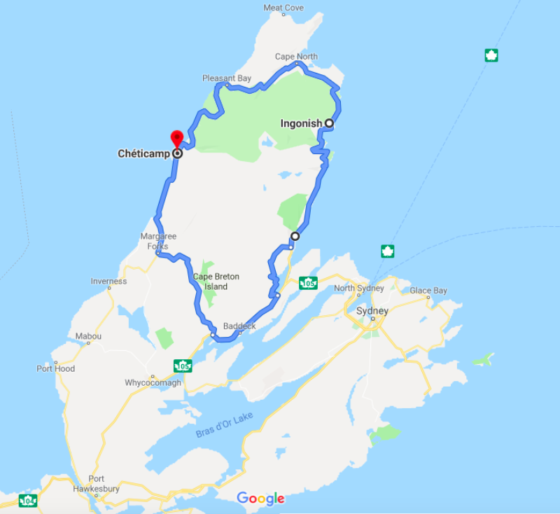
Looking for a map of the Cabot Trail? No worries! Here’s one below.
If you found this post helpful to you, Pin it!
